History
The origins of the Great Polish Map of Scotland are closely connected with the history of Polish soldiers who were stationed in Scotland during the Second World War. After the fall of Poland in 1939, many Polish servicemen continued the fight alongside Allied forces and were later based across the United Kingdom. Scotland became one of the principal locations where Polish troops were stationed, trained and organised as part of the Allied defence of Britain. Polish military units were deployed along the east coast of Scotland, where they helped guard against the possibility of German invasion and prepared for future campaigns in Europe.
During these years many Polish soldiers formed strong relationships with local Scottish communities. They lived and trained in Scotland for extended periods, and over time personal connections and friendships developed between Polish servicemen and local residents. These wartime experiences created lasting ties between the two nations.
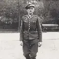
One of the soldiers who served during this period was Jan Tomasik, a member of the Polish forces who later settled in Scotland. After the war Tomasik built a successful career in the hospitality industry and eventually acquired the Black Barony Hotel in the Scottish Borders in 1968. His experiences during the war and his appreciation for Scotland played a significant role in shaping the ideas that would later lead to the creation of the map.
The concept for the project developed during the early 1970s. Tomasik worked closely with Polish academics and geographers, particularly from Jagiellonian University in Kraków. Among the academics involved in the project was cartographer Kazimierz Trafas, who helped design and plan the structure using detailed geographic data and contour mapping techniques.
Work on the map began in 1974 and continued for several years. Construction was carried out largely during the summer months, when visiting Polish geography students and academics travelled to Scotland to take part in the project. Hotel staff, volunteers and local workers also contributed to the physical construction. The process involved marking contour lines, laying brick frameworks and shaping concrete to recreate the landscape. Gradually the terrain of Scotland emerged in relief form, including mountain ranges, island groups and coastal features.
The project continued until the late 1970s, with work generally believed to have been completed around 1979. The finished structure covered a large area of ground and included a surrounding basin designed to hold water representing the seas around Scotland. The intention was that water would flow through channels representing rivers and lochs, adding further realism to the representation of the landscape.
After the late 1970s the site gradually fell into disuse. Changes in hotel ownership and a lack of ongoing maintenance meant that the structure slowly deteriorated over the following decades. Vegetation, weather damage and neglect gradually obscured much of the map’s surface.
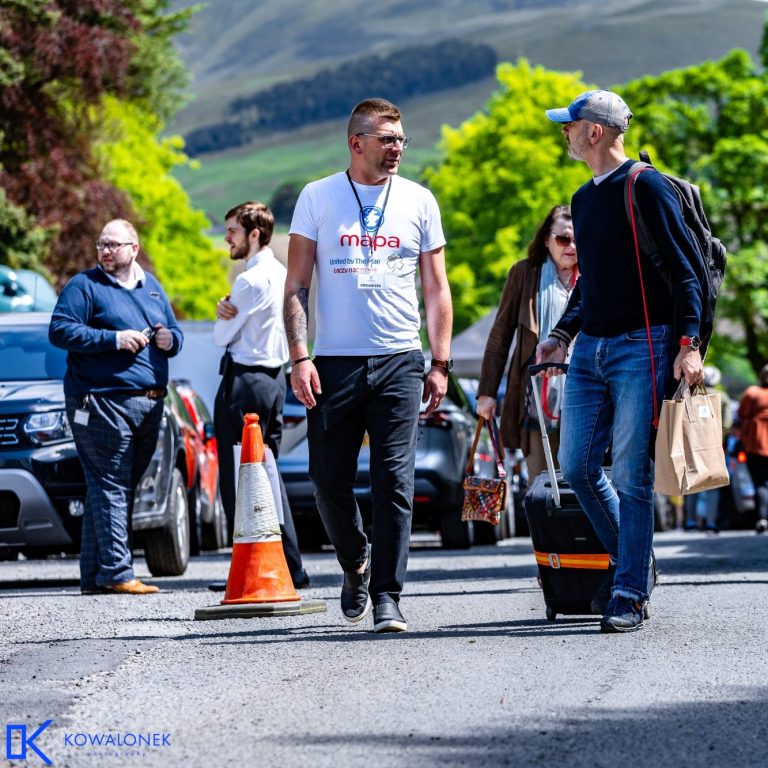
Interest in the site began to grow again in the early twenty-first century, leading to renewed efforts to document and restore the structure. In 2010 the charity Mieczysław's Great Polish Map Appeal (MAPA Scotland) was established with the aim of protecting and restoring the map and preserving the historical story behind its creation.
Through volunteer work, heritage funding and public support, restoration work was undertaken over several years. These efforts eventually led to the reopening of the restored map in 2018, ensuring that the site and its history could once again be experienced by visitors and communities interested in the shared heritage of Poland and Scotland.
Jan Tomasik
The creation of the Great Polish Map of Scotland is closely linked to the vision and determination of Jan Tomasik, a Polish soldier who settled in Scotland after the Second World War. Tomasik served with the Polish armed forces during the war and, like many Polish servicemen, developed a strong connection with Scotland while stationed there. After the war he remained in the country and eventually became a successful hotel owner, purchasing the Barony Castle Hotel (then known as the Black Barony Hotel) in the late 1960s.
Inspired by the kindness shown to Polish soldiers during the war and by his appreciation for Scotland, Tomasik conceived the idea of creating a large-scale relief model of the country in the hotel grounds. Working with Polish geographers from Jagiellonian University, he helped bring together the expertise and support needed to turn this ambitious vision into reality. Construction of the map began in the 1970s, with students, academics and volunteers travelling from Poland to Scotland to take part in the project. Tomasik often described the map as a symbolic gift to the Scottish people, celebrating the friendship and shared history between Poland and Scotland.
Kazimierz Trafas
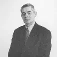
The design and scientific planning of the Great Polish Map of Scotland was led by Kazimierz Trafas, a respected geographer and cartographer from Jagiellonian University in Kraków. Trafas specialised in cartography and spatial modelling, and his expertise was crucial in transforming the idea of a large outdoor terrain model into a technically accurate and workable project.
Working closely with Jan Tomasik, Trafas developed the detailed design of the map using precise geographic data and contour mapping techniques. The project required careful calculation to translate Scotland’s complex landscape into a scaled three-dimensional form. Trafas oversaw the scientific aspects of the project and helped organise the participation of geography students from Jagiellonian University, many of whom travelled to Scotland during the summer months to take part in the construction.
Under his guidance, the team used contour lines based on survey maps to shape the landscape, building up the terrain with brick and concrete before sculpting the mountains, islands and coastlines by hand. Trafas’s work ensured that the map was not only an artistic monument but also a geographically accurate representation of Scotland. His contribution played a fundamental role in turning an ambitious idea into a unique and enduring landmark celebrating Polish-Scottish friendship.
Keith Burns
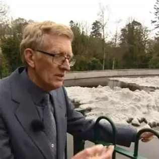
Became one of the early champions of the restoration project.
During visits to the grounds of Barony Castle Hotel, Keith encountered the remains of the large concrete map, which by that time had become heavily overgrown and largely forgotten. Recognising its unique cultural and historical significance, he began researching the monument and sharing its story with others who were interested in preserving it. His work helped bring wider attention to the site and contributed to the growing movement to protect and restore the landmark.
Keith later became actively involved in the restoration campaign and served as a key member of the charity Mieczysław's Great Polish Map Appeal (MAPA Scotland), helping to promote the project and document its history. His dedication, along with the work of many volunteers and supporters, played an important role in ensuring that the Great Polish Map of Scotland was not lost but instead restored for future generations to enjoy.
Grzegorz Kościelak
Following the early restoration efforts led by Keith Burns, Grzegorz became one of the key figures continuing the work of promoting and developing the Great Polish Map project. As interest in the monument grew, Kościelak took on an increasingly active role within Mieczysław's Great Polish Map Appeal (MAPA Scotland), helping guide the organisation through the next phase of its development.
Grzegorz contributed to strengthening connections between Scotland and Poland while supporting the charity’s efforts to raise awareness of the Great Polish Map of Scotland and its historical significance. His involvement has included promoting the map through cultural initiatives, developing partnerships and helping organise events that celebrate the shared heritage between the two nations. By building on the foundations laid by earlier campaigners, Grzegorz has helped and continues helping to ensure that the story of the map continues to reach new audiences while supporting the long-term vision of preserving and promoting this unique landmark.